
How to Choose a Globe: Types, Size and Illumination
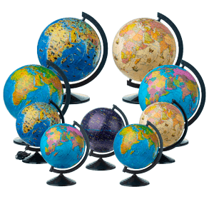
You buy a globe rarely — once every few years, sometimes just once in a whole childhood. So it is worth spending five minutes to choose well: the gap between models is wider than it looks on the shelf. The short version: a globe is a scaled-down, three-dimensional model of the Earth, and it is that three-dimensionality that makes it honest in a way no flat map can be. Areas, distances, angles — all undistorted at once. A wall map simply cannot do that.
Here is what to look at.
Type: what the sphere actually shows
IAT makes four kinds of globe, and they are not interchangeable.
The most universal is the general-geographic one (also called physical): relief, mountains, plains and ocean depths in natural colours. That is the globe to start with. A political globe is a different animal — borders, capitals, each country its own colour; handy when a child reads the news and asks "where is that?". The night-sky globe stands apart: instead of continents it carries constellations and bright stars, so it is the pick for anyone drawn upward rather than down. And the antique-style globe — warm tones, the look of old navigators' charts — is more a piece of decor than a study tool.
Illumination: really two globes in one
This is where people most often slip up. An illuminated globe works in two modes. Lights off, you see the physical map: relief, natural zones. Lights on, the political map shines through, with borders and country names. So for one price you get both maps — plus a quiet night light for a child's room. A non-illuminated globe is cheaper and honestly shows just one thing, which is fine if you need a plain working tool for lessons.
Size: 26 or 32 cm
Two diameters, and the choice is simpler than it seems. 26 cm is compact: it sits on a desk and works well as a gift. 32 cm is the learning standard — a larger scale means larger labels, which means less squinting at tiny place names. If the globe is "for geography" or will stand on a teacher's desk, take the 32. Many of those ship on a wooden stand: steadier, and a more solid look than plastic.
Who needs which
A preschooler does not need detail — they need curiosity. Here a bright 26 cm general-geographic globe with animal imagery wins: it is a first map of the world rather than a reference book.
A student in grades 6–11, though, needs a globe that "talks" to the textbook. Choose a general-geographic or political model at 32 cm — the names on it will match those in the curriculum and the atlases. If you are torn, an illuminated model covers both physical and political geography at once and lasts for years.
A little history, a couple of facts
The oldest surviving terrestrial globe is the "Erdapfel" — literally "earth apple". Martin Behaim made it in Nuremberg in 1492, and one detail is striking: the Americas are not on it — they would be reached that very year, with the sphere already finished.
Something else a globe shows well: Antarctica at its true size. On the familiar wall maps it sprawls along the bottom edge across half the world — not a mistake, but the unavoidable side effect of flattening a sphere onto paper.
Where to buy
Every model — general-geographic, political, night-sky, illuminated and not — is gathered in the globe catalog; from a product card you move on to checkout in the Ukrmaps store.
For schools and institutions, IAT prepares bulk supply with the full Prozorro document package — see the Schools section.


